
Introduction
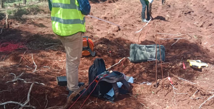
Hydrological Survey in Kenya is a crucial step before borehole drilling, especially as water demand continues to rise across homes, farms, and industries. It ensures that drilling is guided by scientific data rather than guesswork, improving the chances of accessing reliable groundwater sources. This process identifies groundwater availability and helps determine the most suitable drilling location and depth. Moreover, it estimates expected water yield and evaluates the likelihood of success, reducing the risk of drilling dry or low-yield boreholes.
Demand for borehole drilling in Kenya has grown significantly in recent years as more homeowners seek water security, farmers require dependable irrigation sources, and industries look for sustainable water supplies to support their operations. Groundwater offers a dependable alternative to seasonal rivers and municipal water systems, especially in areas affected by water scarcity.
This article explores the meaning of a hydrological survey, the methods used during groundwater exploration, the cost of hydrological surveys in Kenya, and why the process is crucial for successful borehole drilling.
What is a Hydrological Survey?
A hydrological survey is a scientific investigation carried out to locate and evaluate underground water resources before borehole drilling. It helps determine whether sufficient groundwater exists beneath a site and assesses the likelihood of drilling a productive borehole. This process is an important step in groundwater exploration because it provides valuable information that guides drilling decisions and reduces the risk of unsuccessful projects.
Hydrological Survey examines several factors that influence groundwater occurrence and availability. These include the geological characteristics of an area, the movement and storage of groundwater, rainfall patterns, topography, and the presence of existing water sources such as wells, springs, and nearby boreholes. By analyzing these factors together, hydrogeologists can identify areas with favorable conditions for groundwater accumulation and estimate the chances of obtaining a reliable water supply.
Hydrological surveys combine geological observations, geophysical investigations, and field data to build a clear understanding of subsurface conditions. Geological studies examine the types of rocks and soil formations present in an area and identify fractures or faults that may store groundwater. Geophysical methods, such as electrical resistivity surveys, measure the physical properties of underground layers to detect water-bearing formations without excavation. Field data, including information from nearby boreholes, rainfall records, and groundwater levels, is also used to improve the accuracy of the assessment.
The results of a hydrological survey are compiled into a detailed report that recommends the best drilling location, the expected drilling depth, the estimated borehole yield, and the probability of success. This information enables property owners, farmers, businesses, and industries to make informed decisions before investing in borehole drilling.
Why is a Hydrological Survey Important Before Borehole Drilling?
A hydrological survey is a critical step before borehole drilling because it determines whether groundwater is available and whether drilling is likely to be successful. It provides scientific guidance that helps avoid costly mistakes and improves the chances of accessing a reliable water source.
Reduces the Risk of Drilling a Dry Borehole
One of the main benefits of a hydrological survey is reducing the risk of drilling a dry borehole. The survey identifies productive groundwater zones by analyzing underground rock formations, soil types, and water-bearing structures. Through geophysical measurements and geological interpretation, hydrogeologists can locate areas where water is most likely to accumulate, significantly increasing drilling success rates.
Determines the Best Drilling Location
Hydrological surveys help experts choose the most suitable drilling site on a property. Instead of guessing, specialists assess variations in subsurface conditions across the land to pinpoint locations with the highest groundwater potential. This ensures that drilling is done in the most promising position, improving efficiency and water yield outcomes.
Estimates Borehole Depth
Another important function of a hydrological survey is estimating the required drilling depth. By analyzing underground layers and identifying aquifers, survey data helps predict how deep drilling should go to reach water-bearing formations. This prevents unnecessary shallow drilling or excessive deep drilling, both of which can increase costs without improving results.
Predicts Expected Water Yield
Hydrological surveys help estimate the expected water yield from a borehole. By studying aquifer size, permeability, and recharge potential, hydrogeologists can determine how much water the borehole is likely to produce. This information is essential for planning domestic, agricultural, or industrial water usage.
Helps Save Time and Money
Investing in a hydrological survey is more cost-effective than drilling blindly. Without a survey, there is a high risk of drilling in unsuitable locations, leading to dry or low-yield boreholes that require re-drilling. A survey minimizes these risks by guiding the entire drilling process, reducing wasted resources and improving long-term water reliability. Ultimately, the upfront cost of a survey is far lower than the potential losses from unsuccessful drilling attempts.
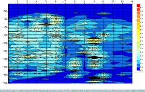
An illustration of a site profile that helps geologist identify a suitable point for drilling
How to Do a Hydrological Survey
A hydrological survey is carried out using a structured scientific process that combines fieldwork, data analysis, and geophysical investigation. The goal is to identify groundwater potential and recommend the best location and depth for borehole drilling.
Step 1: Site Assessment
The first step involves a physical evaluation of the project site. Experts review the topography of the land to understand surface features such as slopes, valleys, and drainage patterns that may influence groundwater movement. Existing water sources such as wells, springs, and nearby boreholes are also examined to determine water availability in the surrounding area.
Geological formations are then assessed to identify rock types and structures that may either store or restrict groundwater. This step helps build an initial understanding of the site’s groundwater potential before detailed investigations begin.
Step 2: Desk Study and Data Collection
The desk study involves collecting and analyzing existing data related to the area. Rainfall records are reviewed to understand long-term recharge patterns that influence groundwater availability. Geological and hydrological maps are also studied to identify regional aquifers, fault lines, and rock formations.
In addition, data from nearby boreholes is assessed, including their depth, yield, and water quality. This information helps create a baseline understanding of groundwater conditions in the area and guides field investigations.
Step 3: Geophysical Investigation
The geophysical investigation is the most technical stage of the hydrological survey. One of the most commonly used methods is the electrical resistivity survey. This technique measures how easily electrical current passes through underground materials.
Different subsurface materials have different resistivity levels. For example, water-bearing formations typically have lower resistivity compared to dry rock layers. By analyzing these variations, hydrogeologists can identify potential aquifers without excavation. This method helps locate underground water-bearing formations and determine their depth and extent.
Step 4: Data Interpretation
After data collection, all field and geophysical results are analyzed and interpreted. Hydrogeologists examine resistivity profiles and geological data to identify the most promising groundwater zones.
This step allows experts to estimate aquifer depth, thickness, and continuity. It also helps determine the likelihood of successfully drilling a productive borehole at the site. Accurate interpretation is essential for making reliable drilling recommendations.
Step 5: Preparation of the Hydrological Survey Report
The final step is compiling all findings into a detailed hydrological survey report. The report summarizes site conditions, geological characteristics, geophysical results, and groundwater potential.
It also provides clear recommendations, including the best drilling location, expected drilling depth, estimated water yield, and any additional considerations such as casing requirements or water quality expectations. This report serves as a guide for borehole drilling contractors and ensures informed decision-making before drilling begins.
Hydrological Survey Methods Used in Kenya
Hydrological surveys in Kenya use a combination of scientific techniques to locate and evaluate underground water resources before borehole drilling. These methods help improve drilling accuracy by identifying areas with high groundwater potential and reducing the risk of unsuccessful boreholes.
Geological Mapping
Geological mapping is one of the foundational methods used in hydrological surveys. It involves studying surface rock formations to understand the subsurface conditions that influence groundwater storage and movement.
Surface rock identification helps determine whether the area consists of permeable or impermeable materials. Permeable rocks such as sandstones and fractured volcanic formations are more likely to store groundwater. Structural analysis is also carried out to identify faults, fractures, and joints in the rock layers. These structures often act as pathways for water movement and are key indicators of potential aquifers.
Electrical Resistivity Method
The electrical resistivity method is the most widely used geophysical technique for groundwater exploration in Kenya. It works by measuring the resistance of underground materials to the flow of electrical current.
Different subsurface materials conduct electricity differently. Water-bearing formations generally have lower resistivity compared to dry or compact rock layers. By injecting electrical current into the ground and measuring the resulting resistance, hydrogeologists can map variations in subsurface layers.
These variations help identify potential aquifers, estimate their depth, and determine their thickness. This method is highly effective because it provides detailed information about underground conditions without the need for excavation.
Remote Sensing and GIS
Remote sensing and Geographic Information Systems (GIS) are modern tools used to analyze large areas quickly and efficiently. Satellite imagery is used to study surface features such as vegetation patterns, drainage systems, and landforms that may indicate groundwater presence.
Digital terrain models help in understanding elevation changes and surface water flow patterns. These models assist in identifying recharge zones where groundwater is likely to accumulate. GIS technology is then used to integrate and analyze all spatial data, making it easier to identify high-potential drilling locations.
Hydrogeological Analysis
Hydrogeological analysis focuses on understanding how groundwater is stored, moved, and replenished within the subsurface environment. One key aspect of this method is groundwater recharge assessment, which evaluates how rainfall and surface water infiltrate into underground aquifers.
Aquifer characterization is also conducted to determine the properties of underground water-bearing formations, including their storage capacity, permeability, and sustainability. This analysis ensures that identified water sources can support long-term usage for domestic, agricultural, or industrial purposes.
Together, these hydrological survey methods form a comprehensive approach that guides successful borehole drilling projects across Kenya.
Hydrological Survey Report: What Does It Contain?
A hydrological survey report is a detailed document prepared after a groundwater investigation. It summarizes field observations, geophysical results, and expert interpretations to guide borehole drilling decisions. The report is an essential tool for determining the most suitable drilling location, depth, and expected water yield.
Site Information
This section provides basic details about the project location. It includes the geographic coordinates of the site, which help accurately identify the drilling position. Land ownership details are also recorded to confirm project authorization. Accessibility information is included to assess how easily drilling equipment can reach the site.
Geological Conditions
The geological section describes the natural subsurface materials found in the area. It outlines the types of rocks present, such as volcanic, sedimentary, or metamorphic formations. It also highlights structural features like fractures and faults, which are important because they often serve as pathways or storage zones for groundwater.
Geophysical Findings
This section presents the results of geophysical investigations, particularly electrical resistivity surveys. Resistivity curves are analyzed to show variations in underground layers. These variations help identify potential aquifers and determine their depth and extent. Aquifer locations are clearly marked to guide drilling activities.
Recommended Drilling Depth
Based on the collected data, the report provides an estimated drilling depth. This indicates how deep drilling should go to reach productive water-bearing formations. It may also include casing requirements to ensure borehole stability and prevent contamination from upper layers.
Estimated Borehole Yield
The report also estimates the expected water output from the borehole. This prediction is based on aquifer size, permeability, and recharge potential. Sustainability considerations are included to ensure that water extraction does not exceed natural replenishment rates.
Recommendations
The final section provides professional recommendations for successful borehole development. It identifies the best drilling site within the property and may suggest additional pumping tests to confirm yield after drilling. Water quality analysis is also recommended to ensure the water is safe for intended use.
Overall, the hydrological survey report serves as a critical decision-making document that improves drilling accuracy and reduces the risk of unsuccessful borehole projects.
Cost of Hydrological Survey in Kenya
A hydrological survey is a key investment before borehole drilling in Kenya. The cost varies depending on several technical and environmental factors, but it plays a major role in improving drilling success and reducing financial risk.
Factors Affecting the Cost
The cost of a hydrological survey in Kenya is influenced by multiple conditions related to the site and the level of investigation required.
- Location of the site: Remote or hard-to-reach areas often attract higher costs due to transport and logistics requirements.
- Accessibility: Sites with poor road access or challenging terrain may require additional equipment and time.
- Survey equipment used: Advanced geophysical instruments and modern data processing tools can increase the overall cost but improve accuracy.
- Geological complexity: Areas with complex underground formations require deeper analysis and more detailed measurements.
- Consultant experience: Highly experienced hydrogeologists and reputable firms may charge more due to expertise and higher success rates.
Average Cost of Hydrological Survey in Kenya
The cost of a hydrological survey in Kenya typically ranges between KSh 50,000 and KSh 80,000, depending on the factors above. In simple and easily accessible areas, the cost may be on the lower end of the range. In contrast, complex geological environments or large-scale projects may require more detailed studies, increasing the cost.
Despite the variation, most professional surveys fall within this general price range, especially for residential, agricultural, and small industrial borehole projects.
Why Prices Vary
Prices differ mainly because no two sites are the same. Groundwater conditions vary widely across Kenya, meaning some locations require simple surface analysis while others need detailed geophysical surveys and advanced interpretation. Additionally, the level of reporting, equipment quality, and turnaround time can also affect pricing. Companies that provide more detailed hydrological reports with higher accuracy tend to charge more due to the added value and reduced drilling risk they offer.
Is the Cost Worth It?
Investing in a hydrological survey is significantly cheaper than the cost of drilling a dry or low-yield borehole. A failed borehole can result in substantial financial loss due to drilling, casing, and mobilization expenses. A proper survey reduces this risk by identifying the most promising drilling locations and estimating expected water yield before any drilling begins. This improves decision-making and increases the likelihood of a successful borehole.
In the long term, a hydrological survey saves money by preventing unnecessary drilling attempts, reducing project delays, and ensuring a reliable water supply for domestic, agricultural, or industrial use.
Equipment Used in Hydrological Surveys
Hydrological surveys rely on specialized equipment and modern technologies to accurately locate and evaluate underground water resources. These tools help hydrogeologists collect, analyze, and interpret data to determine the most suitable locations for borehole drilling.
Hydrological Survey Machine
A hydrological survey machine refers to the set of instruments used in groundwater detection and geophysical investigation. These machines are designed to measure subsurface properties without excavation. They help identify water-bearing formations by analyzing variations in soil and rock resistance, moisture content, and underground structures.
The data collected from these machines is used to estimate aquifer depth, thickness, and potential water yield, making them essential for accurate borehole siting.
Hydrogeological Survey Equipment
Hydrogeological surveys use a variety of professional instruments to study underground water systems. The most commonly used equipment includes:
- Resistivity meters: Used in electrical resistivity surveys to measure how underground layers respond to electrical current. This helps identify aquifers and determine their depth.
- GPS units: Used to accurately record the coordinates of survey points and drilling locations.
- GIS software: Used to analyze and visualize spatial data, including geological maps and groundwater distribution patterns.
- Data loggers: Used to record and store field measurements for later analysis and reporting.
These tools work together to provide a detailed understanding of subsurface conditions and improve the accuracy of groundwater exploration.
Modern Technologies in Hydrological Surveys
Modern hydrological surveys increasingly rely on advanced digital technologies to improve precision and efficiency.
- Mobile survey applications: Used for real-time data collection, field recording, and reporting during site investigations.
- Digital mapping tools: Help create accurate geological and hydrological maps that show groundwater potential zones.
- Remote sensing technologies: Use satellite imagery and aerial data to analyze surface features such as vegetation, drainage patterns, and landforms that indicate groundwater presence.
Together, these modern tools enhance traditional survey methods, allowing hydrogeologists to deliver faster, more accurate, and more reliable results for borehole drilling projects.
Choosing a Hydrogeological Survey Company in Kenya
Selecting the right hydrogeological survey company is a crucial step in ensuring successful borehole drilling. A professional and experienced team increases the chances of locating reliable groundwater sources and reduces the risk of drilling failures.
Experience and Qualifications
Experience plays a major role in the accuracy and reliability of a hydrological survey. Companies with trained hydrogeologists understand how to interpret geological formations, analyze geophysical data, and identify productive aquifers.
Qualified professionals are better equipped to handle complex terrains and make informed recommendations on drilling depth, location, and expected yield. Their expertise directly influences the success rate of borehole projects.
Licensing and Compliance
A reputable hydrogeological survey company should operate under proper licensing and comply with national regulatory requirements. In Kenya, survey professionals are expected to follow standards set by relevant water and environmental authorities.
Compliance ensures that surveys are conducted ethically, scientifically, and in line with legal requirements. It also guarantees that the final hydrological report is recognized and accepted by drilling contractors and regulatory bodies.
Equipment and Technology
The quality of survey results depends heavily on the equipment and technology used. Companies that invest in modern instruments such as resistivity meters, GPS units, GIS software, and data loggers are able to produce more accurate and reliable results.
Advanced technology improves data precision, reduces errors, and provides a clearer understanding of underground water conditions. This leads to better drilling decisions and higher success rates.
Reputation and Previous Projects
A company’s reputation is a strong indicator of service quality. Customer reviews and testimonials provide insight into their reliability, professionalism, and success rate in past projects.
Reviewing previous case studies or completed projects helps clients understand the company’s experience in different geological environments. A proven track record increases confidence in their ability to deliver accurate hydrological surveys and successful borehole recommendations.
Choosing a trusted and well-equipped hydrogeological survey company in Kenya is essential for ensuring long-term water security and minimizing the risks associated with borehole drilling.
Conclusion
A hydrological survey is a vital step before borehole drilling in Kenya. It provides scientific insight into underground water conditions and helps determine whether a site has the potential to produce a reliable water supply. By analyzing geology, groundwater movement, and subsurface formations, the survey guides critical decisions such as drilling location, expected depth, and potential water yield.
Without a proper hydrological survey, borehole drilling becomes a high-risk investment with a greater chance of failure or low water output. However, when the survey is conducted by qualified professionals using the right equipment and methods, it significantly improves drilling success rates and ensures long-term water security.
For homeowners, farmers, and industries, investing in a hydrological survey is not just a technical requirement but a cost-saving strategy. It reduces the risk of dry boreholes, prevents unnecessary expenses, and ensures that every drilling project is based on accurate scientific data.
In the end, a reliable hydrological survey is the foundation of successful borehole development and sustainable groundwater use in Kenya.
Looking for reliable Borehole drilling services? At Antonliner systems limited we offer end to end Borehole drilling services fro hydrological survey to Borehole equipping. Contact us today: 0718 765 936
